.webp)
Understanding elevation changes is one of the most important steps in choosing the right Utah property because elevation influences everything that will eventually matter for long term comfort, cabin building, RV setup, road access, drainage, seasonal use, and the overall experience you will have on the land. Most new buyers focus on how many acres a parcel has or what the views look like, but experienced rural landowners know that the subtle rises, hidden benches, small slopes, and low-lying pockets on a piece of land determine whether the property is forgiving, easy to build on, and enjoyable throughout all four seasons. Elevation is not something you can fix with a shovel, a tractor, or even major grading without spending thousands of dollars. Elevation is part of the land’s permanent character. When you learn how to read elevation changes correctly, you are learning how the land behaves in every season, how water travels across it, where snow lingers, where spring thaw hits hardest, and where you can confidently place a cabin or RV pad that will remain stable and dry for decades.
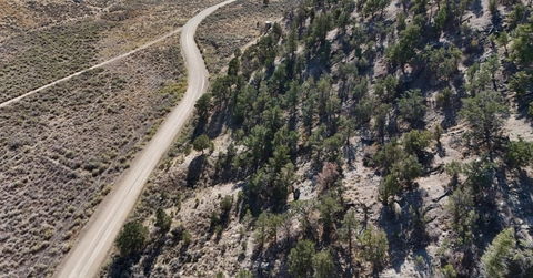
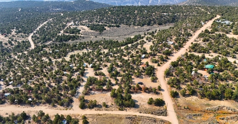
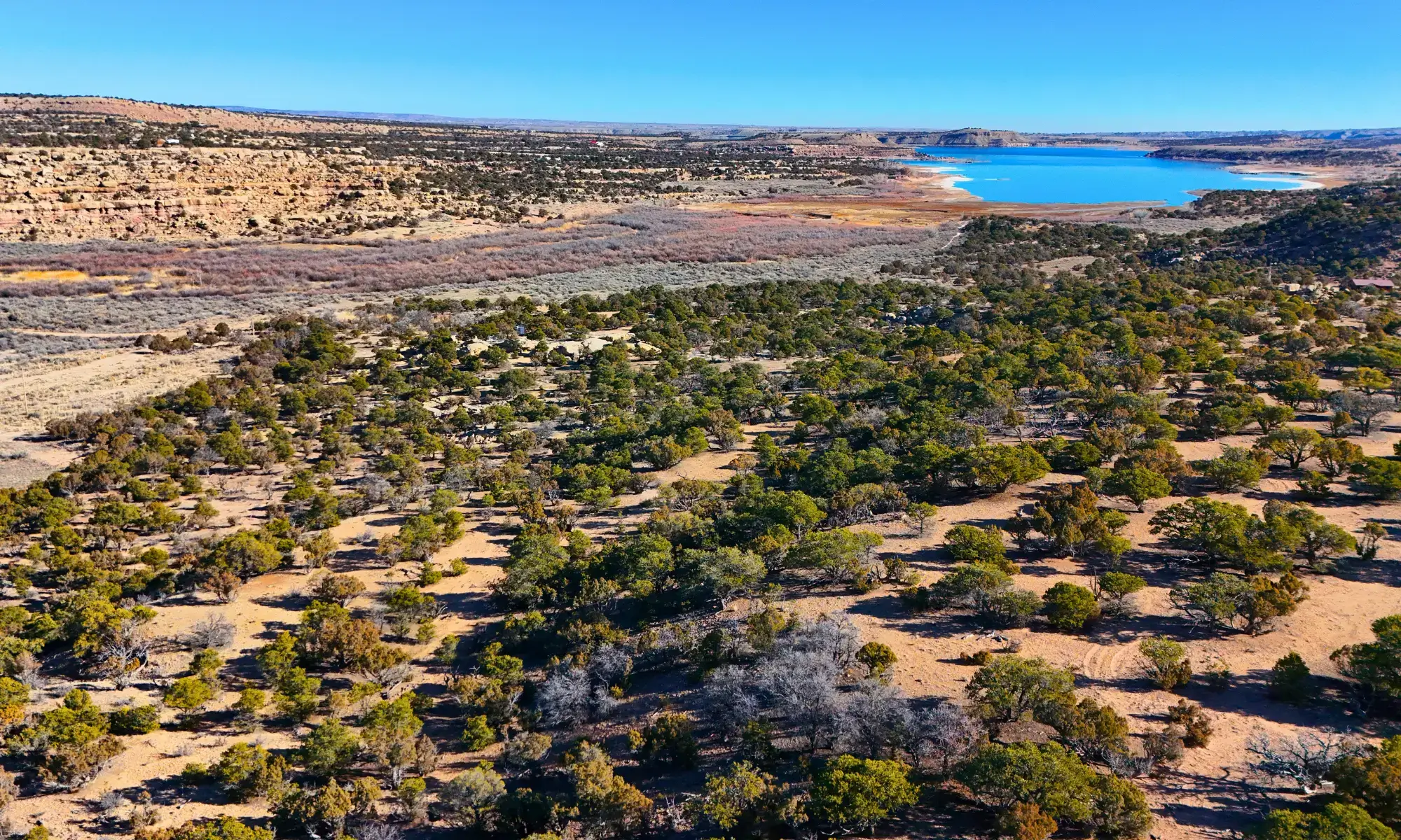
Out in Utah’s high desert and foothill regions, elevation changes tend to be more nuanced than dramatic. You might not see giant cliffs or steep hills, but you will almost always find gentle rises, shallow bowls, natural benches, and small drainage corridors that are extremely important once you begin developing the land. These subtle elevation differences often determine whether your driveway washes out in spring or whether it remains firm, whether your garden gets enough sun, whether water pools next to your cabin, or whether you have to reinforce the soil before building. Understanding these details early helps you avoid costly mistakes, wasted energy, and long term maintenance headaches. It also helps you appreciate the land more deeply because you start to see how the terrain directs wind, sun, water, wildlife, and temperature changes.
Why Elevation Matters When Buying Rural Utah Property
Elevation impacts drainage, soil stability, wind exposure, sun patterns, and long term access. Water always follows gravity, and even the most subtle slope determines where runoff goes during storms, snowmelt, or heavy seasonal rainfall. Many buyers walk their property in summer and assume a certain area is “flat and buildable” because it is dry when they visit. But in Utah, flat low spots often hold moisture during other times of the year, especially in late winter or early spring when the ground thaws unevenly. A seemingly perfect cabin spot may turn into a soggy mess during spring runoff simply because it sits lower than the rest of the parcel. Elevation allows you to predict these behaviors before they cause problems.
Elevation also determines how snow accumulates and melts. Higher benches tend to warm faster in the morning sun, meaning snow melts earlier and access becomes easier. Lower shaded pockets, especially those near tree lines or north facing slopes, can stay icy for weeks longer. This is essential to understand if you plan on visiting your land in winter or spring. Your cabin, driveway, and utility lines will be affected by how sunlight reaches your build site. Elevation also shapes wind patterns. Higher ridgelines may experience strong gusts, while mid-elevation benches may offer a sheltered, comfortable balance. Choosing a build site with the right elevation can lower your heating needs, improve ventilation, and create a more enjoyable outdoor experience.
Elevation factors to consider
- How water drains after rainfall or snowmelt
- Which areas pool water during thaw
- Morning and evening sun exposure
- Soil density and stability at different heights
- Wind exposure or natural wind protection
- Road accessibility during wet seasons
How to Read Slopes, Rises, and Natural Contours
To read elevation correctly, you need to combine visual observation, on-the-ground experience, and an understanding of how natural terrain behaves. Start by slowly walking the property and feeling the changes beneath your feet. A slope that looks flat on camera may feel noticeably angled when you walk across it. Pay attention to how your body shifts as you move. If you consistently lean forward or backward while walking, the slope is stronger than it appears.
Look for natural clues that indicate elevation change. Vegetation is a major indicator. Thick shrubs, especially sagebrush clusters or tall grasses, often grow in low areas where water collects. In contrast, rocky soil or sparse vegetation often marks higher, drier ground. You may also see slight terraces in the land that formed from years of natural erosion. These terraces often create natural building benches. Watch how sunlight hits different parts of the land. High ground brightens early during sunrise, while low areas stay shaded longer. This helps you identify depressions that may not be obvious at first glance.
Utah’s terrain often includes micro contours that are small but meaningful. A shallow wash one foot deep can channel surprising amounts of water during seasonal storms. Low stretches with softer soil can reveal where water once flowed. Even slight depressions can turn into mud pockets during wet seasons. Always walk the property from multiple angles. The best way to understand elevation is by experiencing it directly across different paths, not just from one direction.
Common elevation clues
- Thicker vegetation in low spots
- Exposed rock near ridgelines or high points
- Small dips or channels revealing water flow
- Sunlight reaching higher ground first
- Sparsely vegetated patches marking elevated areas
- Terraced terrain created by erosion
How Elevation Affects Drainage and Build Sites
Drainage is the most critical element influenced by elevation. Even if a property looks completely dry, water has a natural path it takes across the land. Higher elevation areas push water downhill, creating invisible drainage lines that only become obvious during storms. If you build in a place where water naturally wants to go, you will deal with moisture issues, erosion, and structural instability long term. This is why elevated benches are among the best building sites. They stay dry, provide natural airflow, and often require minimal soil prep.
Driveways are particularly sensitive to elevation. A driveway that cuts across a natural drainage path may erode or rut every spring unless reinforced with gravel or road base. Meanwhile, a driveway located on slightly higher ground may remain firm and usable through all seasons. Elevation also affects septic system placement. Septic systems require well draining soil, and placing them in low areas may lead to waterlogging or system failure. Gardens benefit from elevation too because soil warms faster on higher ground and receives more sunlight.
Field testing is one of the best ways to understand how elevation affects drainage. Walk the land after a storm if possible. Look for puddling, soft soil, erosion marks, or exposed roots. These signs reveal how water interacts with the terrain. You can also study contour maps or use simple digital tools to identify where elevation rises and falls. This extra step gives you a clear advantage when planning your future cabin or homestead layout.
Ideal building elevation patterns
- High benches with strong natural drainage
- Elevated slopes with firm soil
- Slight rises away from seasonal washes
- South facing elevated pads for sunlight
- Areas with visible airflow and minimal moisture
Wind Patterns Influenced by Elevation
Wind behavior is shaped heavily by elevation. Higher ridgelines tend to experience stronger, more consistent winds because there are fewer obstructions. While this can be unpleasant during winter storms, it can also offer cooling airflow during summer. Mid-elevation benches often offer the best balance of ventilation and protection. Low pockets, especially those near tree lines, may experience stagnant air or colder temperatures during winter.
Understanding wind patterns helps you choose healthier, more comfortable build sites. Strong winds can strain structures, increase heating needs, and affect solar panel stability. Placing your cabin slightly downhill from a ridgeline often creates a sheltered environment that remains comfortable without sacrificing views.
How Elevation Shapes Temperature and Seasonal Comfort
Temperature varies dramatically with elevation. Even on a single property, a difference of just a few feet in elevation can create measurable changes in warmth, frost levels, and snowpack duration. Higher areas receive sunlight earlier in the morning, warming the soil and melting snow faster. Low areas may trap cold air, making mornings significantly colder. This affects everything from your cabin’s heating efficiency to whether your garden survives late frosts.
Elevation also shapes summer comfort. Elevated breezy areas stay cooler in the evenings and benefit from better airflow, while low basins may trap heat throughout the day. Understanding these temperature differences helps you design a property layout that feels comfortable year round without relying heavily on artificial heating or cooling.
Closing Thoughts
Elevation is one of the most important natural features to understand when buying Utah land. The way the ground rises, falls, drains, and interacts with sunlight determines how your property behaves during storms, heat waves, winter freezes, and spring thaw. When you understand elevation, you gain control over how you design your cabin site, driveway, utilities, and long term homestead layout. By choosing elevated, stable, well draining ground, you build a foundation that supports comfort, safety, and long term enjoyment for decades. Taking the time to study elevation now ensures that your future improvements sit on land that works with you instead of against you.
.webp)

%20(446%20x%20128%20px)%20(306%20x%20105%20px)%20(2)%20(1).webp)


