
MOUNTAINS WEST RANCHES
Subdivisions
-

Buck Horn Mesa
Buck Horn Mesa is one of our most scenic and private subdivisions, located just outside Duchesne, Utah. This area offers large, wooded lots with a peaceful spot for off-grid living, weekend getaways, or long-term land investment. With nearby access to reservoirs, ATV trails, and wide-open wilderness, Buck Horn Mesa combines seclusion with outdoor adventure.
-

Golden Eagle
Golden Eagle is a popular subdivision in Duchesne County, known for its wide, open landscapes. The lots here are spacious and mostly flat, making them easy to build on or set up for camping, RVs, or off-grid living. Whether you’re looking for a weekend getaway or a place to put down long-term roots, Golden Eagle offers a peaceful, rural setting with plenty of freedom.
secluded, lake views, proximity to starvation reservoir.
-

Fruitland Farms
Fruitland Farms is a beautiful subdivision in the heart of Fruitland, Utah, known for its easy access, wide-open views, and close proximity to both Highway 40 and local amenities. These lots offer flat, usable land—perfect for building a cabin, placing a manufactured home, or setting up your weekend getaway. With utilities nearby and year-round road access, Fruitland Farms is one of the most convenient spots for rural living. Just minutes from Red Creek Reservoir and surrounded by miles of open country, it’s a great location for outdoor lovers, families, or anyone looking to own land in a peaceful, small-town setting.
These properties are for residential builders and potentially commercial. Each one has irrigation water.
* -

Lake Side Acres
Lake Side Acres is a highly sought-after subdivision located just minutes from Starvation Reservoir, making it perfect for anyone who loves easy lake access and outdoor recreation. These properties offer a unique mix of open space and rolling terrain, with many lots featuring views of the lake or surrounding hills. With easy road access and a quiet, rural feel, it’s a prime spot for creating your own getaway near one of Utah’s best reservoirs.
-
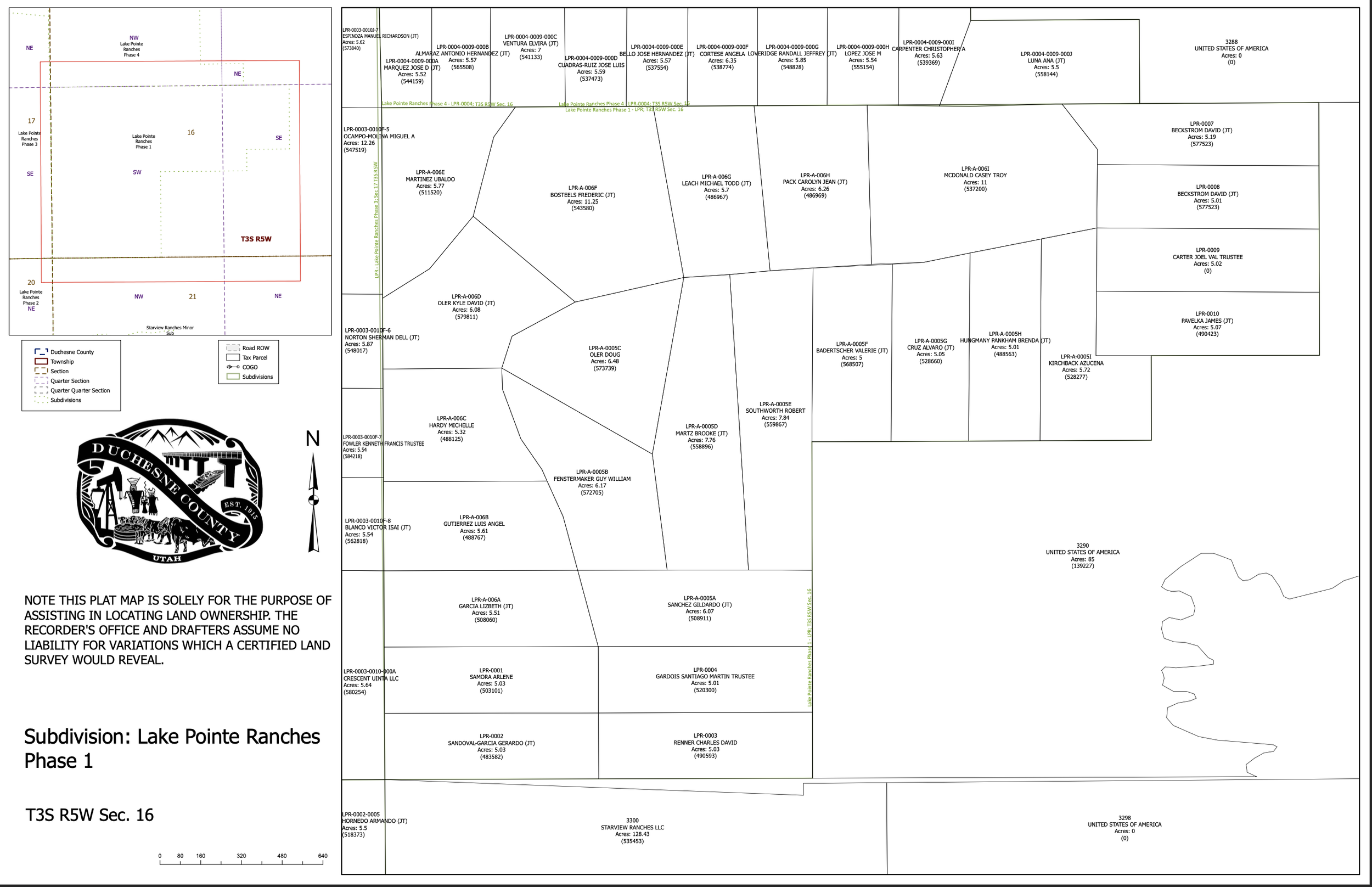
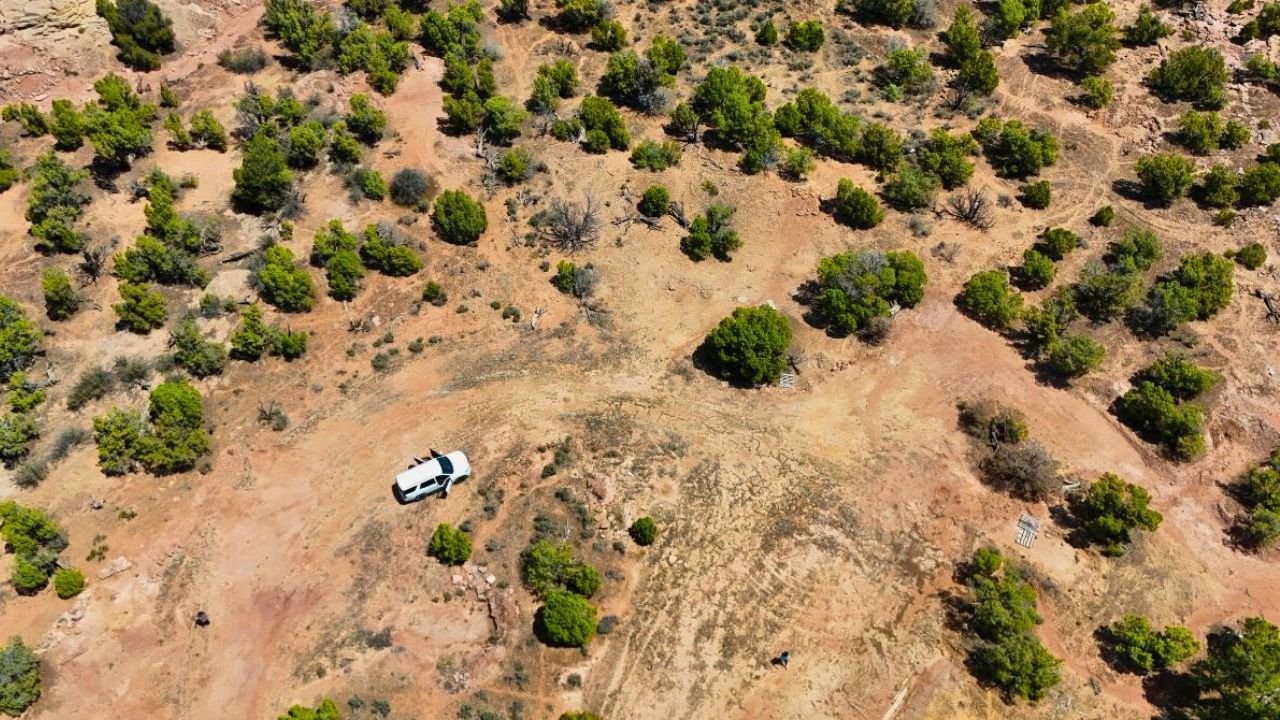
Lake Pointe Ranches
Lake Pointe Ranches is a private subdivision located just north of Starvation Reservoir, offering large acreage lots with open views and plenty of space to spread out. These properties are ideal for off-grid living, camping, or long-term investment, with a peaceful rural setting that feels far away from the noise but still close to town and the lake. Many lots have gentle slopes with a flat pad, making them easy to build on or use for recreational setups. Whether you’re looking to park a trailer, build a cabin, or explore the surrounding hills, Lake Pointe Ranches puts you right in the middle of Utah’s outdoor beauty with room to make it your own.
-

Conejo Hills
Conejo Hills is a secluded subdivision nestled in the hills north of Starvation Reservoir, offering a mix of privacy, elevation, and expansive views. The terrain here is a blend of fully flat terrain and open clearings, making it ideal for building a cabin, camping, or developing your own off-grid retreat. Many lots feature cut driveways or pads, and some include water rights, adding value and flexibility for future use. With wide-open skies, quiet surroundings, and close proximity to recreation areas, Conejo Hills is a great option for anyone looking to own land with both potential and peace in rural Utah.
many that have power on the properties or near the property*
-

Caravan Lane
This subdivision in Duchesne features A5 zoning and comes with valuable water rights, offering flexibility for residential, agricultural, or recreational use. The property has a mix of open ground and mature juniper trees, creating a balance of usable space and natural cover. Gentle terrain runs through the land.
-

Canyon View Ranches
Canyon View Ranches in Duchesne offers A5 zoning and included water rights, giving you flexibility for both residential and agricultural uses.. With plenty of space for building, grazing, or planting, the land is ready for a variety of uses. The rock bluffs add character and privacy, while the A5 zoning allows room for livestock and small-scale farming.
-

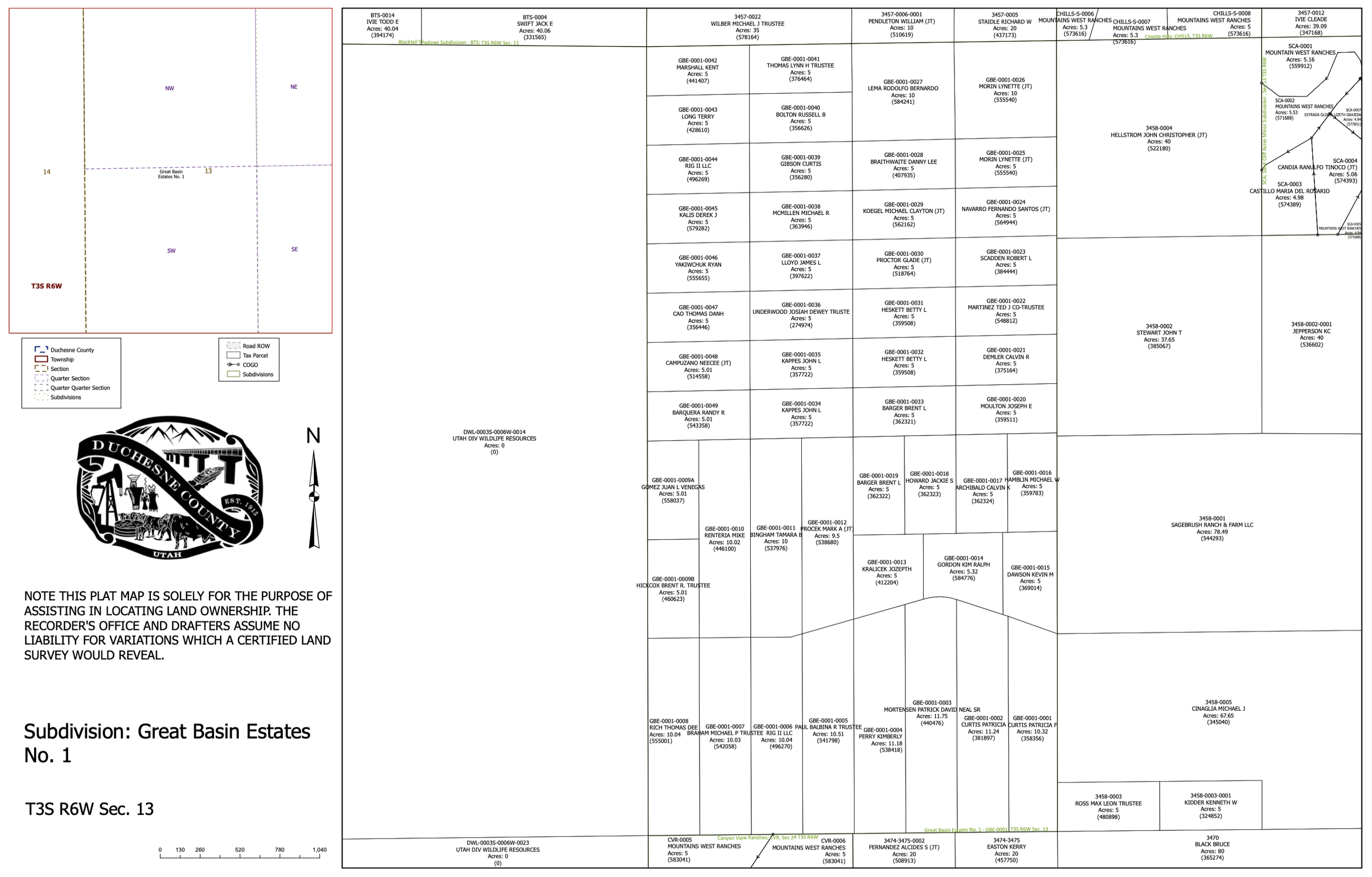
Great Basin Estates
Great Basin Estates in Duchesne offers expansive views, varied terrain, and A5 zoning with water rights included. The property features a mix of level areas, rocky landscapes, and scattered juniper trees, creating both usable space and natural character.
-

Knight Ranches
Knight Ranches in Duchesne offers wide-open space with A5 zoning and included water rights, making it a versatile choice for building, farming, or recreation. The land features flat, usable terrain with low brush, providing plenty of room for a home, barn, or agricultural projects.
-

Lake Wood Estates
Lakewood Estates in Duchesne offers stunning views overlooking the reservoir, paired with A5 zoning and included water rights. The property features rolling terrain with mature juniper trees and open spaces, giving you options for building, recreation, or small-scale agriculture. Elevated vantage points capture sweeping lake and mountain views, while the surrounding community provides a peaceful rural setting with room to spread out.
-

Ranches at Cedar Hollow
Ranches at Cedar Hollow in Duchesne offers a mix of open ground and mature juniper trees, with A5 zoning and water rights included for versatile land use. The property features gently rolling terrain and established tree cover, creating natural privacy while leaving plenty of space for building, recreation, or small-scale agriculture. Accessible roads lead through the land, making it easy to reach your future homesite, campsite, or pasture area.
-

Sundance West
Sundance West is a subdivision in Duchesne, Utah, offering wide-open views, native vegetation, and a peaceful setting. Located in a quiet area with convenient nearby road access, it’s well-suited for recreational use, camping, or building an off-grid retreat. The land includes valuable water rights, giving you more options for future use and development.
-

Cedar Mountain
Cedar Mountain offers spacious lots with a blend of open meadows, scattered trees, and sweeping views of the surrounding high desert. Many properties here feature year-round access, nearby utilities, and plenty of room for cabins, RVs, or recreational use. The area is known for its quiet setting, fresh air, and easy access to nearby towns and outdoor activities.
-

Pinnacle Hills
Pinnacle Hills features large lots with rolling terrain, native vegetation, and wide-open views of the surrounding hills and valleys. Many properties here have year-round access and are suitable for cabins, RVs, or full-time homes. The area offers a quiet, private setting while still being within reach of nearby towns, reservoirs, and recreation areas.
-

Pinion Ridge
Pinion Ridge offers spacious parcels with a mix of open land and pinyon-juniper trees, creating both privacy and usable space. The area is known for its wide views, fresh air, and peaceful setting. Many properties here have year-round access and are suitable for cabins, RVs, camping, or full-time living. Its location provides a balance of seclusion while still being within driving distance of local services and outdoor recreation.
-

Coyote Hills
Coyote Hills features roomy parcels with a blend of open grassland, native vegetation, and scattered trees. The area offers expansive views, fresh air, and a peaceful setting ideal for recreation, camping, or building a cabin or full-time home. Many properties here have year-round access and are located within a short drive of local towns, reservoirs, and outdoor activities.
-

Great Basin Estates
Great Basin Estates in Duchesne offers expansive views, varied terrain, and A5 zoning with water rights included. The property features a mix of level areas, rocky outcroppings, and scattered juniper trees, creating both usable space and natural character. Elevated spots provide sweeping vistas of the surrounding valley and mountains, making it ideal for a future cabin, off-grid retreat, or recreational base. With plenty of room for building, gardening, or livestock, the land is well-suited for multiple uses. The combination of accessible open ground, rugged landscape, and included water rights adds both practicality and long-term value.
-
Rocky Ridge
Rocky Ridge offers spacious lots with a mix of rocky landscapes open ground, and native vegetation. The area provides wide-open views and a quiet setting, making it ideal for camping, building a cabin, or setting up a full-time home. Many properties here have year-round access and are located within reach of local towns, reservoirs, and public land for recreation.
-

River View Estates
River View Estates features spacious lots with expansive views of the surrounding hills, valleys, and nearby river corridors. Many properties offer year-round access, a mix of open space and native vegetation, and potential for cabins, RVs, or full-time homes. The location combines privacy and outdoor recreation.
-

Sage Meadows
Sage Meadows offers open, level parcels with wide views of the surrounding mountains and high desert landscape. The area is known for its peaceful setting, fresh air, and easy access to nearby roads. Many properties here have year-round accessibility and are well-suited for cabins, RVs, camping, or full-time living.
-

Valle Del Padres
Valle del Padres features spacious parcels with a mix of open meadows and native vegetation, set against the backdrop of Utah’s high desert and surrounding hills. Many properties here offer year-round access and are suitable for cabins, RVs, camping, or full-time homes.
-
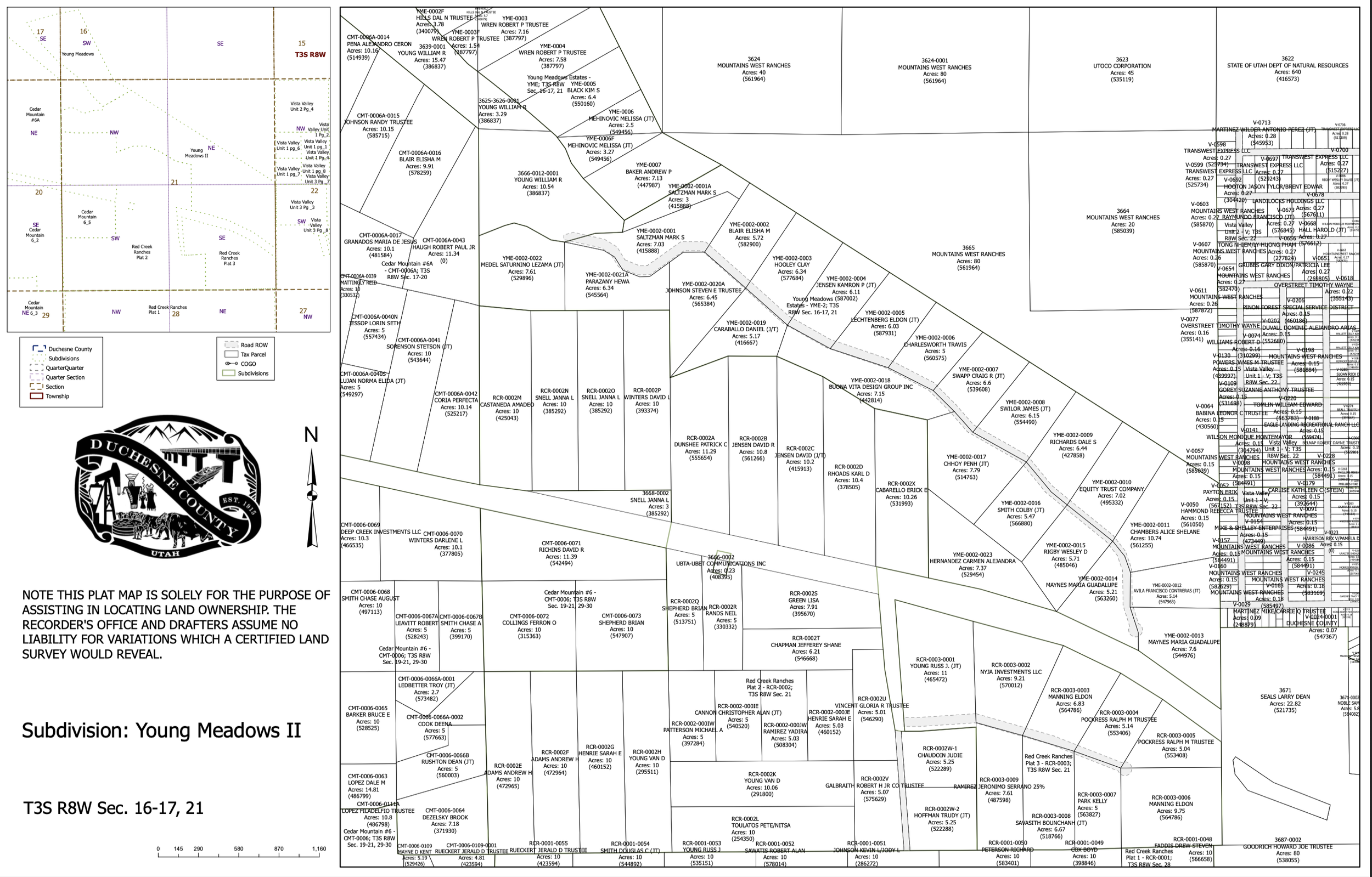
Young Meadows Estates
Young Meadows Estates features open, level parcels with panoramic views of the surrounding mountains. The area offers a peaceful setting with fresh air and plenty of space for recreation or development. Many properties here have year-round access and are suitable for cabins, RVs, camping, or full-time homes. The flat terrain makes building straightforward while still providing room for outdoor activities.
-

Wasatch Meadows
Wasatch Meadows offers spacious parcels with open meadows, scattered trees, and expansive views of the Wasatch Mountains and surrounding high desert. Many properties feature year-round access and are suitable for cabins, RVs, camping, or full-time living. The area provides a quiet, scenic setting while still being within driving distance of nearby reservoirs, and outdoor recreation spots.
-

Vista Valley
Vista Valley features spacious parcels with wide-open views of the surrounding hills, valleys, and high desert landscape. Many properties here offer year-round access and a mix of level ground and gentle slopes, making them suitable for cabins, RVs, camping, or full-time homes. The area is known for its peaceful atmosphere, fresh air, and proximity to local towns, reservoirs, and public land for recreation.
-

Red Creek Ranches
Red Creek Ranches offers large parcels with a blend of open spaces, rolling hills, and native vegetation. The area is known for its scenic views, quiet atmosphere, and easy access to outdoor recreation, including nearby reservoirs and public lands. Many properties here have year-round access and are suitable for cabins, RVs, camping, or full-time living, making it a versatile choice for both investment and personal use.
-

Tabby Heights
Tabby Heights offers large parcels with elevated views of the surrounding mountains, valleys, and high desert scenery. Some properties here feature year-round access, nearby utilities, and a mix of ops**ground and natural vegetation. The area provides a quiet setting ideal for cabins, RVs, camping, or full-time homes, with easy access to reservoirs, and outdoor recreation areas.
*may require 4×4 or snow mobile for high altitude propetude
-

Uintah View Ranches
Uintah View Ranches offers spacious parcels with panoramic views of the Uintah Mountains and surrounding high desert. Many properties here feature year-round access, nearby utilities, and a mix of open meadows and native vegetation. The area is ideal for cabins, RVs, camping, or full-time homes, providing a peaceful setting while still being close to local towns, reservoirs, and public land for outdoor recreation.
m**ainly flat**